


penitents

Clo0413
User
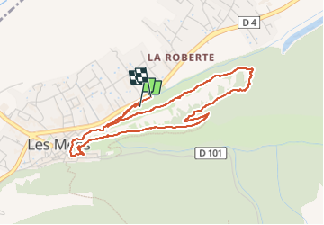

Length
4.9 km

Max alt
589 m

Uphill gradient
222 m
Km-Effort
7.9 km

Min alt
408 m

Downhill gradient
230 m
Boucle
Yes
Creation date :
2024-12-02 08:37:45.389
Updated on :
2024-12-02 11:04:34.085
1h44
Difficulty : Medium

FREE GPS app for hiking
 SityTrail
IGN / Geographical institutes
SityTrail Plus
The world is yours!
About
Trail Walking of 4.9 km to be discovered at Provence-Alpes-Côte d'Azur, Alpes-de-Haute-Provence, Les Mées. This trail is proposed by Clo0413.
Positioning
Country:
France
Region :
Provence-Alpes-Côte d'Azur
Department/Province :
Alpes-de-Haute-Provence
Municipality :
Les Mées
Location:
Unknown
Start:(Dec)
Start:(UTM)
739140 ; 4879757 (31T) N.
Comments